Log in
All resources
Create a design
593 Free Images of Maps Made In The 17th Century
national library of poland
maps by willem and johannes blaeu
atlas ou representation du monde universel t. 2 (1633)
maps by hendrik hondius the younger
willem blaeu
maps by nicolaes visscher i
nicolaes visscher
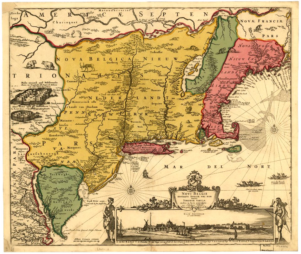
maps of nieuw nederland
atlas van loon
bibliothèque nationale de france
works by georg matthäus vischer
1678 maps
maps of the west-indische compagnie
1800 maps of the united states
maps by alexis-hubert jaillot
maps by nicolas sanson
old maps of rhineland-palatinate
old maps of alsace
maps in the library of congress
adriaen van der donck
maps in the library of congress
adriaen van der donck
maps in the library of congress
adriaen van der donck
old maps of the united states
copper engravings
engravings
1637
lawrence h. slaughter collection of english maps, charts, globes, books and atlases
maps of nieuw nederland
maps in the library of congress
adriaen van der donck
maps by willem and johannes blaeu
maps made in the 17th century
maps made in the 17th century
old maps of china
siege of lingen 1605
maps of lingen (ems)
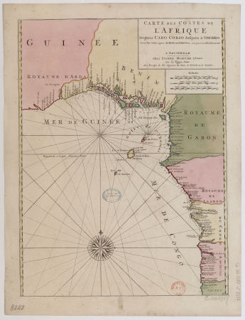
17th-century maps of africa
maps from gallica
old maps of nova belgica et anglia nova
maps made in the 17th century
old maps of westerwolde
maps of vlagtwedde
maps made in the 17th century
old maps of sicily
old maps of roermond
upper guelders
maps made in the 17th century
forts in the netherlands
maps made in the 17th century
johannes van keulen
portolan charts made in the 17th century
maps by willem and johannes blaeu
maps made in the 17th century
old maps of overijssel
maps by willem and johannes blaeu
maps of erkelenz
maps made in the 17th century
guelders
historical
history
maps made in the 17th century
old maps of drenthe
old maps of the new kingdom of granada
1680
eran laor cartographic collection
pierre aveline
eran laor cartographic collection
pierre aveline
maps made in the 17th century
old maps of lindau (bodensee)
maps made in the 17th century
1630s maps of taiwan
maps made in the 17th century
old county maps of cornwall
maps made in the 17th century
old maps of gelderland
maps made in the 17th century
novi belgii, atlas maior
17th-century maps of the mediterranean sea
portolan charts made in the 17th century
portolan charts made in the 17th century
maps by willem and johannes blaeu
old maps of ravenstein, germany
maps made in the 17th century
maps made in the 17th century
africa settentrionale
maps by willem and johannes blaeu
maps made in the 17th century
maps by willem and johannes blaeu
maps made in the 17th century
maps by willem and johannes blaeu
17th-century maps of the world
maps by nicolas sanson
jan van somer
maps made in the 17th century
lazio
cartouches by willem and johannes blaeu
maps made in the 17th century
maps by jodocus hondius
1610 maps of europe
native american history of virginia
17th-century maps of virginia
atlas ou representation du monde universel t. 2 (1633)
17th-century maps of southeast asia
maps by willem and johannes blaeu
maps made in the 17th century
maps by willem and johannes blaeu
maps made in the 17th century
maps made in the 17th century
old maps of upper austria
maps by willem and johannes blaeu
maps made in the 17th century
plenilunii lumina austriaca philippica
maps from gallica
17th-century maps of the mediterranean sea
1610 maps of europe
crux (constellation)
willem blaeu
maps made in the 17th century
old maps of alsace
columba (constellation)
willem blaeu
cartouches by willem and johannes blaeu
maps made in the 17th century
atlas ou representation du monde universel t. 2 (1633)
nicolaes visscher i
atlas ou representation du monde universel t. 1 (1633)
17th-century double hemisphere world maps
maps by willem and johannes blaeu
maps made in the 17th century
atlas ou representation du monde universel t. 1 (1633)
17th-century maps of scandinavia
atlas ou representation du monde universel t. 1 (1633)
maps by hendrik hondius the younger
maps of novaya zemlya
1590s maps
atlas ou representation du monde universel t. 2 (1633)
17th-century maps of peru
atlas ou representation du monde universel t. 2 (1633)
17th-century maps of bermuda
atlas ou representation du monde universel t. 2 (1633)
17th-century maps of paraguay
atlas ou representation du monde universel t. 2 (1633)
maps by hendrik hondius the younger
atlas ou representation du monde universel t. 2 (1633)
maps by hendrik hondius the younger
atlas ou representation du monde universel t. 2 (1633)
maps by hendrik hondius the younger
atlas ou representation du monde universel t. 2 (1633)
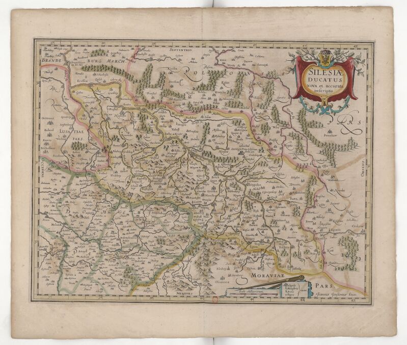
17th-century maps of silesia
atlas ou representation du monde universel t. 2 (1633)
17th-century maps of italy
atlas ou representation du monde universel t. 2 (1633)
maps by hendrik hondius the younger
atlas ou representation du monde universel t. 2 (1633)
17th-century maps of chile
maps in the rijksmuseum amsterdam
gerard valck
mappe-monde geo-hydrographique (sanson and jaillot, 1674)
cartography of france
17th-century maps of the mediterranean sea
portolan charts made in the 17th century
atlas ou representation du monde universel t. 2 (1633)
17th-century maps of the strait of magellan
eran laor cartographic collection
claes jansz. visscher (ii)
maps by joachim bormeester
1680s maps of the world
pacific ocean in art
ships on maps
atlas ou representation du monde universel t. 2 (1633)
17th-century maps of austria
historical
history
old maps of groningen (city)
egbert haubois
1740s maps of the world
maps by emanuel bowen
maps by pieter mortier
le neptune francois
1696 maps of the caribbean
1690s maps of mexico
atlas, ou représentation du monde universel et des parties d'icelui, faicte en tables et descriptions très amples et exactes, divisé en deux tomes. édition nouvelle... - btv1b53103889w
17th-century maps of guyana
mappe-monde geo-hydrographique (sanson and jaillot, 1674)
atlas, ou représentation du monde universel et des parties d'icelui, faicte en tables et descriptions très amples et exactes, divisé en deux tomes. édition nouvelle... - btv1b53103889w
17th-century maps of silesia
atlas, ou représentation du monde universel et des parties d'icelui, faicte en tables et descriptions très amples et exactes, divisé en deux tomes. édition nouvelle... - btv1b53103889w
17th-century maps of chile
maps by joachim bormeester
1685 maps
maps made in the 17th century
claes jansz. visscher (ii)
501 - 593 of 593
/ 6


![Gerardi Mercatoris and I. Hondii Atlas or Representation of the Universal World, and of the Parts of It, Made in Tables and Very Ample Descriptions. [t. 2].](https://cdn.creazilla.com/illustrations/10000597422/gerardi-mercatoris-and-i-hondii-atlas-or-representation-of-the-universal-world-and-of-the-parts-of-it-made-in-tables-and-very-ample-descriptions-t-2-md.jpg)


![Plenilunii lumina Austriaca Philippica / [Michael Florent van Langren], between 1650 and 1675](https://cdn.creazilla.com/illustrations/10001512015/plenilunii-lumina-austriaca-philippica-michael-florent-van-langren-between-1650-and-1675-md.jpg)


![Gerardi Mercatoris and I. Hondii Atlas or Representation of the Universal World, and of the Parts of It, Made in Tables and Very Ample Descriptions. [t. 2]., Nicolaes Visscher](https://cdn.creazilla.com/illustrations/10000298847/gerardi-mercatoris-and-i-hondii-atlas-or-representation-of-the-universal-world-and-of-the-parts-of-it-made-in-tables-and-very-ample-descriptions-t-2-nicolaes-visscher-sm.webp)
![Gerardi Mercatoris and I. Hondii Atlas or Representation of the Universal World, and of the Parts of It, Made in Tables and Descriptions Very Ample, and Exact: Divided into Two Volumes [...]. [t. 1].](https://cdn.creazilla.com/illustrations/10000622971/gerardi-mercatoris-and-i-hondii-atlas-or-representation-of-the-universal-world-and-of-the-parts-of-it-made-in-tables-and-descriptions-very-ample-and-exact-divided-into-two-volumes-t-1-md.jpg)

![Gerardi Mercatoris and I. Hondii Atlas or Representation of the Universal World, and of the Parts of It, Made in Tables and Descriptions Very Ample, and Exact: Divided into Two Volumes [...]. [t. 1].](https://cdn.creazilla.com/illustrations/10001541341/gerardi-mercatoris-and-i-hondii-atlas-or-representation-of-the-universal-world-and-of-the-parts-of-it-made-in-tables-and-descriptions-very-ample-and-exact-divided-into-two-volumes-t-1-md.jpg)
![Gerardi Mercatoris and I. Hondii Atlas or Representation of the Universal World, and of the Parts of It, Made in Tables and Descriptions Very Ample, and Exact: Divided into Two Volumes [...]. [t. 1].](https://cdn.creazilla.com/illustrations/10001462413/gerardi-mercatoris-and-i-hondii-atlas-or-representation-of-the-universal-world-and-of-the-parts-of-it-made-in-tables-and-descriptions-very-ample-and-exact-divided-into-two-volumes-t-1-md.jpg)

![Gerardi Mercatoris and I. Hondii Atlas or Representation of the Universal World, and of the Parts of It, Made in Tables and Very Ample Descriptions. [t. 2].](https://cdn.creazilla.com/illustrations/10000378633/gerardi-mercatoris-and-i-hondii-atlas-or-representation-of-the-universal-world-and-of-the-parts-of-it-made-in-tables-and-very-ample-descriptions-t-2-sm.webp)
![Gerardi Mercatoris and I. Hondii Atlas or Representation of the Universal World, and of the Parts of It, Made in Tables and Very Ample Descriptions. [t. 2].](https://cdn.creazilla.com/illustrations/10000384995/gerardi-mercatoris-and-i-hondii-atlas-or-representation-of-the-universal-world-and-of-the-parts-of-it-made-in-tables-and-very-ample-descriptions-t-2-sm.webp)
![Gerardi Mercatoris and I. Hondii Atlas or Representation of the Universal World, and of the Parts of It, Made in Tables and Very Ample Descriptions. [t. 2].](https://cdn.creazilla.com/illustrations/10000511702/gerardi-mercatoris-and-i-hondii-atlas-or-representation-of-the-universal-world-and-of-the-parts-of-it-made-in-tables-and-very-ample-descriptions-t-2-sm.webp)
![Gerardi Mercatoris and I. Hondii Atlas or Representation of the Universal World, and of the Parts of It, Made in Tables and Very Ample Descriptions. [t. 2].](https://cdn.creazilla.com/illustrations/10000841463/gerardi-mercatoris-and-i-hondii-atlas-or-representation-of-the-universal-world-and-of-the-parts-of-it-made-in-tables-and-very-ample-descriptions-t-2-md.jpg)
![Gerardi Mercatoris and I. Hondii Atlas or Representation of the Universal World, and of the Parts of It, Made in Tables and Very Ample Descriptions. [t. 2].](https://cdn.creazilla.com/illustrations/10000199512/gerardi-mercatoris-and-i-hondii-atlas-or-representation-of-the-universal-world-and-of-the-parts-of-it-made-in-tables-and-very-ample-descriptions-t-2-sm.webp)
![Gerardi Mercatoris and I. Hondii Atlas or Representation of the Universal World, and of the Parts of It, Made in Tables and Very Ample Descriptions. [t. 2].](https://cdn.creazilla.com/illustrations/10000416251/gerardi-mercatoris-and-i-hondii-atlas-or-representation-of-the-universal-world-and-of-the-parts-of-it-made-in-tables-and-very-ample-descriptions-t-2-sm.webp)
![Gerardi Mercatoris and I. Hondii Atlas or Representation of the Universal World, and of the Parts of It, Made in Tables and Very Ample Descriptions. [t. 2].](https://cdn.creazilla.com/illustrations/10000404015/gerardi-mercatoris-and-i-hondii-atlas-or-representation-of-the-universal-world-and-of-the-parts-of-it-made-in-tables-and-very-ample-descriptions-t-2-sm.webp)
![Gerardi Mercatoris and I. Hondii Atlas or Representation of the Universal World, and of the Parts of It, Made in Tables and Very Ample Descriptions. [t. 2].](https://cdn.creazilla.com/illustrations/10000831433/gerardi-mercatoris-and-i-hondii-atlas-or-representation-of-the-universal-world-and-of-the-parts-of-it-made-in-tables-and-very-ample-descriptions-t-2-sm.webp)
![Gerardi Mercatoris and I. Hondii Atlas or Representation of the Universal World, and of the Parts of It, Made in Tables and Very Ample Descriptions. [t. 2].](https://cdn.creazilla.com/illustrations/10001307107/gerardi-mercatoris-and-i-hondii-atlas-or-representation-of-the-universal-world-and-of-the-parts-of-it-made-in-tables-and-very-ample-descriptions-t-2-sm.webp)
![Gerardi Mercatoris and I. Hondii Atlas or Representation of the Universal World, and of the Parts of It, Made in Tables and Very Ample Descriptions. [t. 2].](https://cdn.creazilla.com/illustrations/10001531963/gerardi-mercatoris-and-i-hondii-atlas-or-representation-of-the-universal-world-and-of-the-parts-of-it-made-in-tables-and-very-ample-descriptions-t-2-sm.webp)


![Gerardi Mercatoris and I. Hondii Atlas or Representation of the Universal World, and of the Parts of It, Made in Tables and Very Ample Descriptions. [t. 2].](https://cdn.creazilla.com/illustrations/10001243780/gerardi-mercatoris-and-i-hondii-atlas-or-representation-of-the-universal-world-and-of-the-parts-of-it-made-in-tables-and-very-ample-descriptions-t-2-sm.webp)


![Gerardi Mercatoris and I. Hondii Atlas or Representation of the Universal World, and of the Parts of It, Made in Tables and Very Ample Descriptions. [t. 2].](https://cdn.creazilla.com/illustrations/10001210086/gerardi-mercatoris-and-i-hondii-atlas-or-representation-of-the-universal-world-and-of-the-parts-of-it-made-in-tables-and-very-ample-descriptions-t-2-sm.webp)